19 interesting places of Turkmenistan that are worth seeing with your own eyes
11.11.2022 | 14:30 |The territory of Turkmenistan is an amazing world of the ancient and medieval East. Here, after millennia, the buildings of the first states and outstanding sights of Central Asia have been preserved. We offer the most extensive list of historical, natural, archaeological, climatic monuments of the country that are worth visiting at least once in your life. With brief information and a route to get to them.
The ancient city of Merv
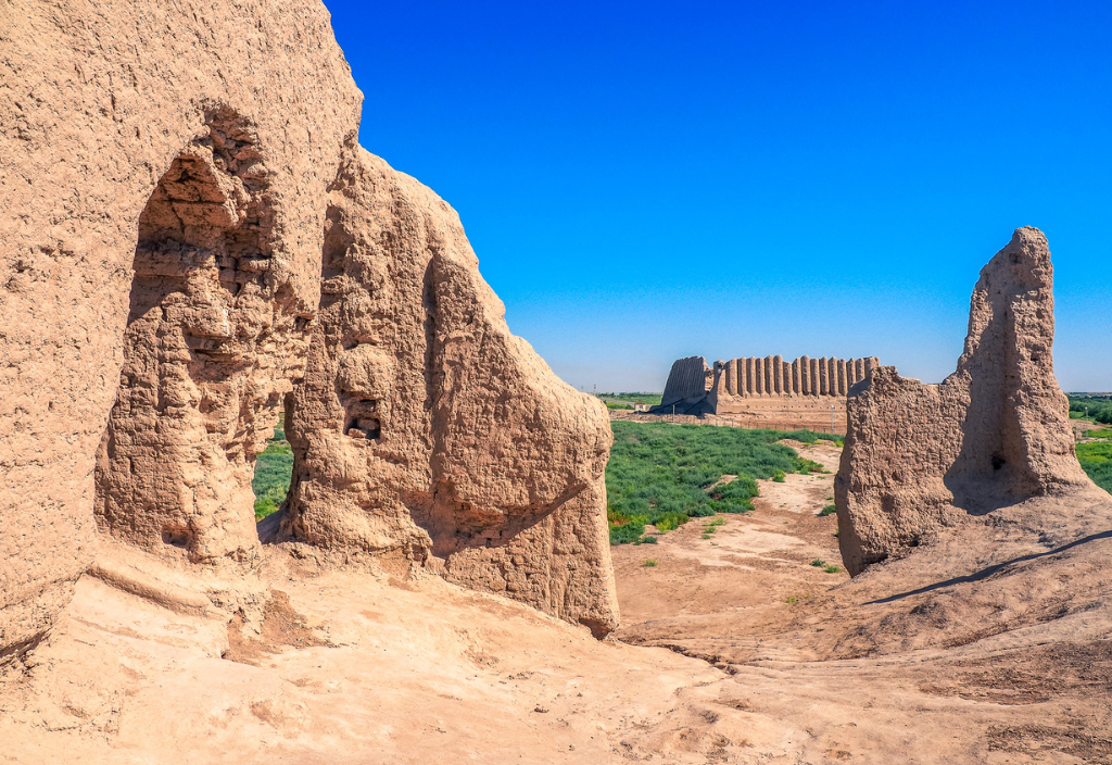
It was included in the UNESCO World Heritage List as the best preserved ancient center of the Great Silk Road. It is the oldest known city in Central Asia. At one time, it was the capital of Margiana and the Seljuk Turkic Empire. Famous thinkers Omar Khayyam, As-Samani and others lived and worked here.
The ruins include five ancient settlements — Erk-Kala, Gyaur-Kala, Sultan-Kala, Abdullahan-Kala and Bayramalihan-Kala. Most of them are badly destroyed, some of them are only earthen hills. Archaeological finds discovered during excavations can be seen in the Historical Museum of Merv.
Attractions: mausoleum of Sultan Sanjar Dar-al-Ahir, Sultan-Kala, citadel of Shazriar-Ark, ruins of the walls of Abdullahan-Kala, ruins of the fortress of Kyz-Kala (VI-VII centuries AD), mausoleums of Al-Hakim ibn Amir al-Jafari and Burayda ibn al-Hussein al-Islami (a place of pilgrimage), Talhatan Baba complex with mausoleums, ruins of Erk-Kala fortress (VI century), Kyz-Bibi mausoleum, Haram-Keshk castle, Durnali settlement (I-II centuries), numerous remains of baths, palaces, ceremonial halls and other structures.
How to get there? Located in the southeastern part of Turkmenistan, 30 km east of the modern city of Mary, near the city of Bayramali.
The Parthian Capital

Today Nisa is the ruins of an ancient city, the earliest traces of which date back to the IV century BC. It consists of the New (Parthian city in the valley) and the Old (royal fortress on a hill) Nisa.
Attractions: Square House, Square Hall, Round Temple.
Nisa is one of the most important historical monuments of Turkmenistan from the antiquity. Samples of Parthian wall paintings and architectural decorations are now in the Museum of Fine Arts named after Saparmurat Turkmenbashi. Rhitons, marble statues, precious finds from royal tombs are exhibited in the halls of the National Museum of Turkmenistan.
In 2007, Nisa was included in the UNESCO World Heritage List. Also included in the list are Merv and Kunyaurgench. Nisa is Located 18 km west of Ashgabat.
Kunyaurgench Architectural Reserve

Kunyaurgench is the ancient capital of Northern Horezm, one of the largest cities of the Great Silk Road. The remains of the oldest fortress of the city of Kyrkmolla belong to the II-V century AD.
In the middle of the VIII century, the city became the second largest city after Buhara. In 1221, it was the "heart of Islam". To date, many monuments of Kunyaurgench are in a badly destroyed state.
Attractions: Kyrkmolla fortress, mosques, caravanserai gates, fortresses, mausoleums and minarets of the XI-XVI centuries, mausoleums of Najimetdin al-Kubr and the Mongolian princess Tyubarek-hanym, Kutlug-Timur minaret (the highest in Central Asia), ibn Hajiba madrasah, "360 saints" necropolis, Ak -Kala fortress.
Where is located: The city is the administrative center of Kunyaurgench district of Dashoguz region (480 km north of Ashgabat).
The capital of a semi-mythical country

Gonurdepe is a Bronze Age settlement (2300 BC), located in the south-east of Turkmenistan, in the Mary oasis. Discovered in 1972 by the Margian Archaeological Expedition. Gonurdepe was the largest settlement in Margiana — a capital city with a palace and several temples. Its area is not precisely established, and according to various estimates is from 20 to 50 hectares. The temple city existed until the end of the XVI century BC.
Attractions: the Temple of Fire — the earliest known, a complex of public meals (north), two pools, a temple of Water, a large necropolis — found 350 m west of the central part. It has been excavated for 10 years and has almost 3,000 burials), the royal necropolis.
In each of the royal tombs, samples of art, gold treasures and mosaic panels were found. These mosaics are by far the earliest narrative mosaic paintings in the world. Clay and ceramic vessels, gold and silver jewelry, cylindrical seals from Mesopotamia and a square seal from Harappa were also found.
Interestingly, before the archaeological excavations, the ancient civilization of Margush (Margiana) was considered a semi-mythical country.
How to get there: Gonurdepe is located 60 km north of the city of Mary.
Dehistan: ghost town
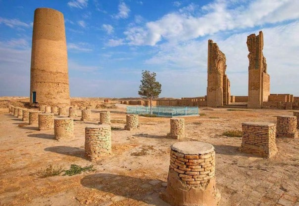
The flat, arid plain of the Balkan region — it was here that the most isolated city on the caravan route between Horezm and Hyrkania once stretched.
Dehistan was located in the heart of the famous Misrian Valley. The data indicate that the city appeared at the turn of the VIII-IX centuries.
Dehistan experienced its greatest development during the reign of the Horezmshahs. Then the city, with an area of about 2000 hectares and a double ring of walls, became a real fortress. What it was like can only be guessed from the ruins that have survived to this day.
It is known that from here it was possible to get to Persia and Turkey through the southern gates, to Buhara, Samarkand and Merv through the eastern ones, and to Russia and Europe through the northern ones.
Attractions: the mausoleum of Shir Kabir, two minarets 25 meters high, the portal of the cathedral mosque, the remains of raw clay city walls, the ruins of caravanserais, mausoleums on the Mashad necropolis.
Located in the Etrek district of the Balkan region in the Misrian Valley in the middle of the desert. It is part of the State Historical and Cultural Reserve "Ancient Dehistan".
Serahs and Abiverd in the Ahal region
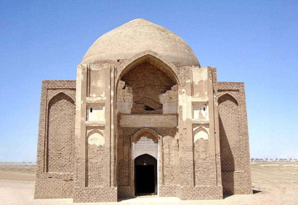
The territory of Serahs and Old Serahs, as well as other historical and architectural monuments located on the territory, is part of the historical and cultural reserve. Serahs is one of the oldest cities in Central Asia. It originated in the Eneolithic era (IV millennium BC). It reached its peak during the reign of the Seljukid dynasty, as it was one of the centers of trade in Central Asia.
Attractions: ruins of the 11th century mausoleum of Yarty-Gumbez 8 km southeast of Serahs, the mausoleum of Abul-Fazla (Serahs-baba) - a square domed building decorated with marble and inscriptions from the Koran, the ancient settlement of Mele Heyran 15 km from the modern city and its Zoroastrian temple of fire (only the lower part of the walls has been preserved and a large altar in the center of the hall).
Abiverd is an ancient city of the Sassanid era, located in the northern part of the Great Horasan. It served as a border town to prevent barbarian raids. Archaeological excavations have discovered several mounds and hills. There was a Bandian Fire Temple near Abiverd.
How to get there? Serahs is the administrative center of the Serahs district, located near the border with Iran. Abiverd is located at the foot of three mountains on the outskirts of the Karakum Desert.
"House of Beauty"

The Seyit Jamal ad-Din Mosque was conceived as a large religious complex and combined ziaratkhana, khanaka and hujras for pilgrims. The hallmark of the complex is a high expressive brick portal with decorative decoration and panels with Arabic epigraphy. Above the arch there was a unique mosaic — two writhing dragons on a background of apple blossoms. This story has ancient local roots and it is the only mosque in the world with images of dragons on the main facade.
It was built by the ruler of Horasan Abul-Qasim Baber Bahadurkhan in 1456 and destroyed during the Ashgabat earthquake in 1948. Only the lower parts of the portal abutments and fragments of the walls have been preserved. Along with the mosque, unique images of dragons also fell under the ruins.
The restorers who won the grant restored the image and today it is on display at the Museum of Fine Arts of Turkmenistan. In addition to the mosaic, scientists restored the foundations of the portal, the brickwork on the square, the grave of Sheikh Jamal al-Din.
How to get there? Located in Anau, 18 km from Ashgabat in the Ahal region.
Dinosaur Plateau. Hojapil

This is a unique place that has no analogues on the planet. Attracts tourists from all over the world. The plateau is a limestone slab measuring 400x300 meters, which tilted at an angle of 120 degrees at an altitude of 1500 meters. About 1,500 pairs of well-preserved dinosaur tracks and 31 trails have been recorded on this territory. This is the largest accumulation of dinosaur footprints on the planet in one place.
Megalosaurs belonging to the Jurassic period moved along 26 trails out of 31. The longest of the trails — 195 m, 226 m, 266 m and 311 m — are world records (previously the record belonged to a 147 m long trail in Mexico). The maximum step length is more than two meters.
Scientists suggest that this area was swampy or shallow water millions of years ago. Gradually, the marshes dried up and petrified. During the mountain-building processes, this place rose above the ground and tilted. Over time, the upper layers of the soil were washed away and the real miracle of paleontology was revealed to people.
Scientific research of the area took place only in the second half of the last century. The discovery of the plateau was accompanied by another sensation — "human-like" footprints with a length of 26 cm were discovered. Six of them have been discovered and their age is 150-200 million years. The origin of these traces is still a mystery.
How to get there? Located in the Koytendag Mountains in the south-east of Turkmenistan. 3 kilometers southwest of the mountain village of Hojapil. Administratively, this place is located in the Magdanly district of the Lebap region on the border with Uzbekistan. The road constantly going up is very difficult. You can get there by SUV.
Ekedeshik Cave Complex

This is a cave city built before our era, and translated from the Turkmen language means "one hole". Based on the name, it becomes clear that the complex has one entrance, so it is almost impregnable.
The cave consists of two floors: on the lower floors, the former inhabitants collected water from underground sources, in the upper ones there were living and kitchen rooms, halls and an altar. In total, the researchers counted 44 rooms. Excavations have proved that people have lived in these caves since the I century BC, presumably with whole families.
It is unknown who created this city and when. Today the cave has the status of a State historical and architectural reserve. Currently, archaeological excavations are continuing, the purpose of which is to reveal the origin of the cave city. Ekedeshik is located in the Tagtabazar district of the Mary region of Turkmenistan, on the left bank of the Murgab River, in the area of the Karabil upland.
By the way, some time ago, as a result of the collapse of a section of one of the slopes, the entrances to another previously unknown cave city near the villages of Dashkepri and Erden were exposed. The walls of the Dashkepri complex are more representative than the Ekedeshik cave.
However, archaeologists have not yet conducted a deep study of this area.
Karluk caves

The incredible beauty of the Koitendag karst caves. "Kap Kutan", "Hoshmoyik", "Gulshirin", "Tashyurek", "Tazecharva" and dozens of others — together form a unique natural dungeon of Koytendag. Karluk caves are the most famous in Turkmenistan. These are typical manifestations of various forms of karst. In total, about 60 caves have been registered, the total length of which is more than 50 km. Caves have galleries, passages, halls, labyrinths. In them there are sinter formations of gypsum, calcite, aragonite in the form of stalactites, stalagmites, stone curtains, etc.
Terrain in craters and sinkholes filled with water. All caves branch out into many small passages and manholes. The height of the vaults is up to 10 meters, and the sizes of the sinter formations reach up to 6 meters. In some caves, underground galleries run in an imperceptible circle.
The largest and longest (and most popular among tourists) is the Cap-Kutan cave. This is one of the longest cave systems in the world! Today, 60 km of this cave has been studied, although it has not been fully studied.
The most "new" is the "Intermediate" cave. There are wells, labyrinths, tube-like passages, narrow passages with plaster flowers, halls with plaster "chandeliers", an underground lake. The docking of the caves "Intermediate" and Cap-Kutan was searched for 15 years.
The most beautiful — "Gulshirin" — is located to the northeast of the cave "Hoshimoyik". A narrow winding passage, a spacious hall with huge blocks of limestone, plaster stalactite "fir trees", "stone waterfalls", "Gothic columns", "curtains" made of marble onyx. But, the rock formation dangerously hangs near the entrance. At any moment, the entrance to the cave (and exit) may become blocked.
Another small cave "Tashyurek" is located 1.5 km north of the cave "Cap-Kutan". The Karluk caves are unique natural monuments that have no equal in the whole of Eurasia. Therefore, they are included in the UNESCO World Heritage List.
How to get there? "Kap-Kutan" is located on the western slope of the Kugitangtau ridge in the buffer zone of the Kugitang Reserve. The natural entrance to the cave is located 7 km north-east of the village of Karluk in the Koytendag district of the Lebap region.
Baharden Cave. Kov-Ata Lake

One of the most famous and visited tourist sites of Turkmenistan. The Baharden cave is a 250—meter hall, the height of which decreases from 26 meters at the entrance to 3 meters near the lake itself, located at a depth of 55 meters. The air temperature is 20-25 ° C in winter and 27-32 ° C in summer. And the water temperature is 37 °C.
The underground lake is considered curative because its water is rich in hydrogen sulfide and 26 other chemical elements. Archaeologists claim that the cave has been visited by people for more than 2000 years. Today it is equipped with a concrete ramp, an observation deck and lighting. This negatively affected the colony of bats. Out of more than 400 thousand, only a few tens of thousands remain.
Located in the foothills of Kopetdag in the Baharden district of the Ahal region (20 km from the village of Bakharden and 120 km from Ashgabat).
Yangykala (fiery rocks, Pink Canyon)
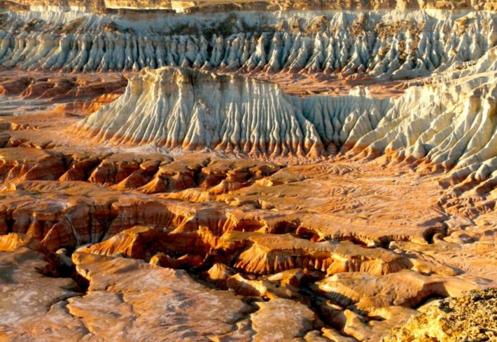
The area on the ancient Ustyurt plateau. This "unearthly" surface was once under water and formed over millions of years on the site of an ancient ocean. The rich red color of the canyons is due to the mineral composition — the presence of iron. The sands and clay have weathered, and the mineral substance, gradually compacting, turned into stones.
The canyon is located south of Garabogaz Bay in the northwest of the Balkan region of Turkmenistan.
Darvaza

The gas crater in Turkmenistan, burning for more than 50 years, is known all over the world. In 1971, a drilling rig collapsed and a crater was formed from which gas was escaping. In order not to poison the environment, the gas was set on fire, and it is still burning.
Located in the Karakum desert, 90 km from the village of Yerbent, Dashoguz region. The only nearest cafe is a few kilometers south of the crater. And shops can be found only in Yerbent. When traveling, it should be taken into account that the last few kilometers to the crater pass along a sandy stretch that can only be driven by an SUV.
Mud volcanoes
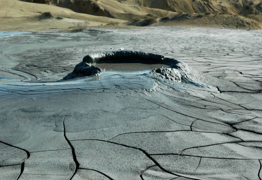
The coast of the ancient Caspian Sea with a monotonous desert landscape stretching for hundreds of kilometers — mud volcanoes have been operating throughout this territory for millions of years. Periodically spewing mud masses and gases, often with hot water and oil. They are active, constantly changing their position. From the most ancient volcanoes there were hills of fossilized materials of eruptions.
What to see: volcanoes in the area of the Hazar Reserve: Boiling hillock Chikishlyar, Ak-Patlauk (the most active, 100 m high and 200 m crater diameter), Kalitsky volcano, Tuinukli, Keimir group, Porsy. To the north, near the village of Chikishlyar, there is a "nomadic volcano" with a diameter of up to 60 m. In 2006, he was at sea, and today he is on land.
Keimir volcano with a diameter of 200 m. and up to 10 m high. — located a few kilometers north of the village of Chikishlyar Volcanoes of the northern group of the Keimir-Chikishlyar district: Ekerem (buried) and Geok-Patlauk, whose height is 150 meters. Boyadag volcano is one of the largest, most beautiful and easternmost. Today it is a highly dissected hill, stretched in width by more than 20 km. Volcanoes Aligul (with the most powerful eruptions), Western Porsugel and Pink Porsugel (are crater lakes).
Located in the South-West of Turkmenistan on an area of more than 300 km long and up to 100 km wide. From the village of Esenguly to Cheleken (Hazar), in the so-called West Turkmen Depression. According to some reports, half of all mud volcanoes in the world are located in Turkmenistan.
Depressions of the Karakum Desert

The Badhyz basin and its Yeroylanduz depression is a deep, drainless depression with an area of 300 square kilometers. In ancient times, the Tethys Sea stretched here. Over time, a unique depression formed on the site of active volcanic foci at the bottom of the sea. Today, you can see domed hills here, representing the vents of extinct volcanoes. In spring and winter, the depression is filled with meltwater, forming a salt lake, and in summer — a flat salt marsh.
The Sarykamysh Basin is a depression in the north of Turkmenistan, is the northern border of the Karakum Desert. Its length is about 150 km, width about 90 km. The absolute height relative to the level of the world ocean is minus 38 meters. It is a flat bowl of oval shape, covered with salt marshes and sifted sands. The Sarykamysh Lake is located in the central part.
Akchakaya is the deepest drainage basin located near the city of Dashoguz. Its bottom is located below the level of the World Ocean at 81 m . If you look at the depression from space, it resembles a large horseshoe in shape. It has a length of 50 kilometers and a width of about 6 km.
Akchakaya is located in the middle of the Karakum desert in the Dashoguz region of Turkmenistan. It is easier to get to the depression by rail, which runs through the Karakum Mountains. Then — paved roads, and then — on deserted roads.
Garabogaz Bay

An unusual water formation is the bay—lagoon, which is located almost close to the Caspian Sea. They are separated by a narrow spit, and behind it — a narrow strait about 10 km long, and no more than one kilometer in the widest place. The bay is located 4.5 meters below the level of the Caspian Sea. Therefore, the speed of the current reaches 1 meter per second (in some places — up to three meters) and here you can also see such a phenomenon as a sea waterfall. Although its height is only 2 meters.
Garabogaz Bay is the saltiest lake in the world. It is surrounded by a desert and the water has nowhere to go — it evaporates. The salinity of the gulf is 30 times higher than that of the Caspian Sea.
Now salt is mined at this place, so the area turned out to be economically profitable. The landscape of the lake is "tied" to this white salt. It crystallizes everywhere — the shores of the lake look like snow-covered, "icicles" of salt are formed on the coastal bushes.
Location: Turkmenbashi district of the Balkan region.
Life at a height. Nohur

The picturesque mountain village of Nohur is located in the west of the Kopetdag ridge, at an altitude of 1 km above sea level. And the residents cultivate vegetable gardens and orchards at an altitude of 1.8 km .
Old and New Nohur are original two—storey houses on a mountain plateau among grape, almond and pomegranate orchards. Residents grow vegetables and fruits, keep cattle.
Attractions: Nohur waterfall, the cave "House of Deva", the highest point of Kopetdag — the mountain "Three wells", a huge centuries—old plane tree, the place of fulfillment of desires - the gorge "Giz bibi", necropolis.
The village of Nohur is located 145 km from Ashgabat. If you're wondering if it's worth coming here, let's just say that this place is included in the list of "100 most romantic places in the world".
Waterfalls of Turkmenistan

The largest waterfall is Hur-Huri. Geologists compare the structure of this waterfall with Niagara. The width of the Turkmen, of course, is inferior, but they are identical in height. The most beautiful is the Umbara Waterfall. There are dozens of lesser-known, sometimes nameless, but no less beautiful water cascades in the mountains (Kyrk-gyz, Kosh-demir, etc.).
Hur-Huri is located on the Kopetdag ridge in the vicinity of the village of Nohur. Umbar is a Karelian—type waterfall in the gorges of Koytendag in the east of Turkmenistan.
Nature reserves

There are many state reserves in Turkmenistan:
Repetek is located in the Southeastern Karakums in the Lebap region of Turkmenistan, 70 km southwest of the city of Turkmenabad, around the Repetek station.
Badkhyz is located in the Mary region in the south of Turkmenistan. It was created to protect the ecosystems of the Badkhyz plateau between the Kushka and Tejen rivers.
Hazar is a specially protected natural territory of Turkmenistan. It is located in the west of the country, on the southeastern coast of the Caspian Sea (near the city of Turkmenbashi).
Kopetdag is located in the Ahal region, near the city of Ashgabat. The uniqueness is the ancient pistachio fields.
Syunt-Hasardag is located in the Balkan region in the southwest of the country, in the foothills of the peaks of Syunt and Hasar in the southwestern Kopetdag.
Kaplankyr is located on the southern edge of the Ustyurt plateau in the Dashoguz region in the north of Turkmenistan.
Amudarya is a nature reserve in Darganaty, Seyda and Farab districts of Lebap region of Turkmenistan.
Koytendag is located in the district of the same name in the Lebap region. Bereketli-Karakum is located in the northern part of the Ahal region of Turkmenistan, in the Karakum desert.
ORIENT
Photo: Canva, silkadv.com, tourweek.ru Asia Adventures, Alpagama


